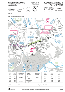
VAC chart of LFOF
 Satellite view of LFOF
Satellite view of LFOF
Sorry, we have no imagery here.
Sorry, we have no imagery here.
Sorry, we have no imagery here.
Sorry, we have no imagery here.
Sorry, we have no imagery here.
Sorry, we have no imagery here.


LFOF - Alencon Valframbert
Located in Alencon, France
ICAO - LFOF, IATA - XAN
Data provided by AirmateGeneral information
Coordinates: N48°26'48" E0°6'30"
Elevation is 476 feet MSL.
Magnetic variation is 0.36° East View others Airports in Lower Normandy
Operational data
Special qualification required
Current time UTC:
Current local time:
Communications frequencies: [VIEW]
Runways:
| RWY identifier | QFU | Length (ft) | Width (ft) | Surface | LDA (ft) |
| 07L | 69° | 2395 | 262 | GRASS | 1804 |
| 25R | 249° | 2395 | 262 | GRASS | 1804 |
| 07R | 69° | 2559 | 59 | ASPH | 1886 |
| 25L | 249° | 2559 | 59 | ASPH | 1952 |
Airport contact information
Address: Alencon France
Other aviation service providers
Aviation club (not for profit)

Aéroclub d'Alençon et sa Région
Aéroclub d'Alençon et sa Région
contact@aeroclub-alencon.org+33233292586
Association de Voltige Alençonnaise
Association de Voltige Alençonnaise
alainodolant@sfr.fr+33233276183
Satellite view of LFOF
Sorry, we have no imagery here.
Sorry, we have no imagery here.
Sorry, we have no imagery here.
Sorry, we have no imagery here.
Sorry, we have no imagery here.
Sorry, we have no imagery here.