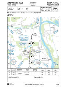
VAC chart of LFKY
 Satellite view of LFKY
Satellite view of LFKY
Sorry, we have no imagery here.
Sorry, we have no imagery here.
Sorry, we have no imagery here.
Sorry, we have no imagery here.
Sorry, we have no imagery here.


LFKY - Belley-Peyrieu
Located in , France
ICAO - LFKY, IATA -
Data provided by AirmateGeneral information
Coordinates: N45°41'38" E5°41'30"
Elevation is 739 feet MSL.
Magnetic variation is 2.04° East View others Airports in Rhône Alpes
Operational data
Special qualification required
Current time UTC:
Current local time:
Weather at : LFLB - Chambery Aix Les Bains ( 16 km )
METAR: LFLB 102300Z AUTO 19001KT CAVOK 07/04 Q1022
TAF: TAF LFLB 101400Z 1015/1115 01010KT CAVOK BECMG 1102/1104 VRB02KT
Communications frequencies: [VIEW]
Runways:
| RWY identifier | QFU | Length (ft) | Width (ft) | Surface | LDA (ft) |
| 18 | 185° | 2093 | 197 | GRASS | 1768 |
| 36 | 5° | 2093 | 197 | GRASS | 1772 |
Airport contact information
Address: France
Other aviation service providers
Aviation club (not for profit)

Aéroclub de Belley-Peyrieu
Aéroclub de Belley-Peyrieu
secretaire@aeroclub-belleypeyrieu.fr+33479420019
Satellite view of LFKY
Sorry, we have no imagery here.
Sorry, we have no imagery here.
Sorry, we have no imagery here.
Sorry, we have no imagery here.
Sorry, we have no imagery here.