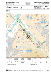
VAC chart of LFKE
 Satellite view of LFKE
Satellite view of LFKE
Sorry, we have no imagery here.
Sorry, we have no imagery here.
Sorry, we have no imagery here.
Sorry, we have no imagery here.
Sorry, we have no imagery here.
Sorry, we have no imagery here.


LFKE - Saint Jean En Royans
Located in , France
ICAO - LFKE, IATA -
Data provided by AirmateGeneral information
Coordinates: N45°1'35" E5°18'33"
Elevation is 872 feet MSL.
Magnetic variation is 1.95° East View others Airports in Rhône Alpes
Operational data
Special qualification required
Current time UTC:
Current local time:
Weather at : LFLU - Valence Chabeuil ( 29 km )
METAR: LFLU 101130Z AUTO 32013KT CAVOK 20/05 Q1022
Communications frequencies: [VIEW]
Runways:
| RWY identifier | QFU | Length (ft) | Width (ft) | Surface | LDA (ft) |
| 14 | 144° | 2188 | 164 | GRASS | 1991 |
| 32 | 324° | 2188 | 164 | GRASS | 2188 |
Airport contact information
Address: France
Other aviation service providers
Aviation club (not for profit)

Satellite view of LFKE
Sorry, we have no imagery here.
Sorry, we have no imagery here.
Sorry, we have no imagery here.
Sorry, we have no imagery here.
Sorry, we have no imagery here.
Sorry, we have no imagery here.