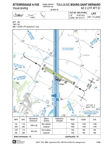
VAC chart of LFIT
 Satellite view of LFIT
Satellite view of LFIT
Sorry, we have no imagery here.
Sorry, we have no imagery here.
Sorry, we have no imagery here.
Sorry, we have no imagery here.
Sorry, we have no imagery here.
Sorry, we have no imagery here.


LFIT - Toulouse Bourg Saint Bernard
Located in , France
ICAO - LFIT, IATA -
Data provided by AirmateGeneral information
Coordinates: N43°36'40" E1°43'27"
Elevation is 526 feet MSL.
Magnetic variation is 1.06° East View others Airports in Midi-Pyrénées
Operational data
Special qualification required
Current time UTC:
Current local time:
Weather at : LFBO - Toulouse Blagnac ( 29 km )
METAR: LFBO 130730Z AUTO 33008KT 5000 RA BR SCT006/// BKN011/// BKN034/// ///CB 13/12 Q1011 BECMG NSW BKN016
TAF: TAF AMD LFBO 130615Z 1306/1412 31008KT 9999 BKN016 TEMPO 1306/1308 5000 -RA BKN007 SCT030TCU BECMG 1310/1312 BKN030 TEMPO 1316/1320 SCT030TCU BECMG 1319/1321 25005KT CAVOK PROB40 TEMPO 1403/1409 SCT006 BKN030 BECMG 1403/1405 VRB02KT BECMG 1409/1411 13014KT
Communications frequencies: [VIEW]
Runways:
| RWY identifier | QFU | Length (ft) | Width (ft) | Surface | LDA (ft) |
| 12R | 120° | 2297 | 197 | GRASS | 2297 |
| 30L | 300° | 2297 | 197 | GRASS | 2297 |
| 12L | 120° | 3937 | 164 | GRASS | 3609 |
| 30R | 300° | 3937 | 164 | GRASS | 3609 |
Airport contact information
Address: France
Other aviation service providers
Aviation medical examiner

Satellite view of LFIT
Sorry, we have no imagery here.
Sorry, we have no imagery here.
Sorry, we have no imagery here.
Sorry, we have no imagery here.
Sorry, we have no imagery here.
Sorry, we have no imagery here.