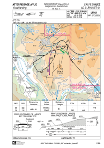
VAC chart of LFHU
 Satellite view of LFHU
Satellite view of LFHU
Sorry, we have no imagery here.
Sorry, we have no imagery here.
Sorry, we have no imagery here.
Sorry, we have no imagery here.
Sorry, we have no imagery here.
Sorry, we have no imagery here.


LFHU - L'alpe D'huez
Located in , France
ICAO - LFHU, IATA - AHZ
Data provided by AirmateGeneral information
Coordinates: N45°5'15" E6°5'1"
Elevation is 6103 feet MSL.
Magnetic variation is 2.14° East View others Airports in Rhône Alpes
Operational data
Special qualification required
Current time UTC:
Current local time:
Weather at : LFLB - Chambery Aix Les Bains ( 63 km )
METAR: LFLB 102330Z AUTO 18003KT CAVOK 06/03 Q1022
TAF: TAF LFLB 101400Z 1015/1115 01010KT CAVOK BECMG 1102/1104 VRB02KT
Communications frequencies: [VIEW]
Runways:
| RWY identifier | QFU | Length (ft) | Width (ft) | Surface | LDA (ft) |
| 06 | 60° | 1470 | 98 | ASPH | 1470 |
| 24 | 240° | 1470 | 98 | ASPH |
Airport contact information
Address: France
Satellite view of LFHU
Sorry, we have no imagery here.
Sorry, we have no imagery here.
Sorry, we have no imagery here.
Sorry, we have no imagery here.
Sorry, we have no imagery here.
Sorry, we have no imagery here.