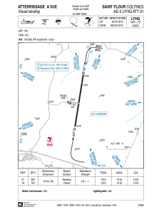
VAC chart of LFHQ
 Satellite view of LFHQ
Satellite view of LFHQ
Sorry, we have no imagery here.
Sorry, we have no imagery here.
Sorry, we have no imagery here.
Sorry, we have no imagery here.
Sorry, we have no imagery here.
Sorry, we have no imagery here.


LFHQ - Saint Flour Coltines
Located in Saint Flour, France
ICAO - LFHQ, IATA -
Data provided by AirmateGeneral information
Coordinates: N45°4'30" E2°59'33"
Elevation is 3218 feet MSL.
Magnetic variation is 1.35° East View others Airports in Auvergne
Operational data
Special qualification required
Current time UTC:
Current local time:
Weather at : LFLW - Aurillac ( 49 km )
METAR: LFLW 071700Z AUTO 29009KT 260V320 CAVOK 19/06 Q1018 NOSIG
TAF: TAF LFLW 071400Z 0715/0724 29006KT CAVOK BECMG 0717/0720 12005KT
Communications frequencies: [VIEW]
Runways:
| RWY identifier | QFU | Length (ft) | Width (ft) | Surface | LDA (ft) |
| 01 | 9° | 4298 | 98 | ASPH | 4298 |
| 19 | 189° | 4298 | 98 | ASPH | 4298 |
Airport contact information
Address: Saint Flour France
Handlers

Fuel provider

Other aviation service providers
Aviation club (not for profit)

Association des pilotes de Haute Auvergne
Association des pilotes de Haute Auvergne
synd.mixte-gest.aero.coltines@orange.fr+33471609495
Club Rsa Des Volcans St Flour
Club Rsa Des Volcans St Flour
club.rsa.des.volcans@laposte.net0695176920
Satellite view of LFHQ
Sorry, we have no imagery here.
Sorry, we have no imagery here.
Sorry, we have no imagery here.
Sorry, we have no imagery here.
Sorry, we have no imagery here.
Sorry, we have no imagery here.