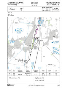
VAC chart of LFHH
 Satellite view of LFHH
Satellite view of LFHH
Sorry, we have no imagery here.
Sorry, we have no imagery here.
Sorry, we have no imagery here.
Sorry, we have no imagery here.
Sorry, we have no imagery here.
Sorry, we have no imagery here.


LFHH - Vienne Reventin
Located in Vienne, France
ICAO - LFHH, IATA - XVI
Data provided by AirmateGeneral information
Coordinates: N45°27'46" E4°49'40"
Elevation is 720 feet MSL.
Magnetic variation is 1.82° East View others Airports in Rhône Alpes
Operational data
Special qualification required
Current time UTC:
Current local time:
Weather at : LFLY - Lyon Bron ( 31 km )
METAR: LFLY 100700Z AUTO 01004KT 330V050 CAVOK 10/03 Q1024 NOSIG
TAF: TAF LFLY 100500Z 1006/1106 34006KT CAVOK
Communications frequencies: [VIEW]
Runways:
| RWY identifier | QFU | Length (ft) | Width (ft) | Surface | LDA (ft) |
| 01 | 12° | 2165 | 164 | GRASS | 1706 |
| 19 | 192° | 2165 | 164 | GRASS | 2165 |
Airport contact information
Address: Vienne France
Other aviation service providers
Aviation club (not for profit)

Satellite view of LFHH
Sorry, we have no imagery here.
Sorry, we have no imagery here.
Sorry, we have no imagery here.
Sorry, we have no imagery here.
Sorry, we have no imagery here.
Sorry, we have no imagery here.