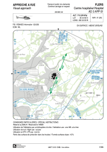
VAC chart of LFH481
 Satellite view of LFH481
Satellite view of LFH481
Sorry, we have no imagery here.
Sorry, we have no imagery here.
Sorry, we have no imagery here.
Sorry, we have no imagery here.
Sorry, we have no imagery here.
Sorry, we have no imagery here.


LFH481 - Flers Centre Hospitalier
Located in , France
ICAO - , IATA -
Data provided by AirmateGeneral information
Coordinates: N48°44'58" W0°32'20"
Elevation is 712 feet MSL.
View others Airports in Lower Normandy
Operational data
Special qualification required
Current time UTC:
Current local time:
Weather at : LFRK - Caen Carpiquet ( 48 km )
METAR: LFRK 071230Z AUTO 03006KT 350V060 CAVOK 16/03 Q1023 NOSIG
TAF: TAF LFRK 071100Z 0712/0721 VRB05KT CAVOK BECMG 0713/0715 02010KT BECMG 0718/0720 VRB05KT
Communications frequencies: [VIEW]
Runways:
Airport contact information
Address: France
Satellite view of LFH481
Sorry, we have no imagery here.
Sorry, we have no imagery here.
Sorry, we have no imagery here.
Sorry, we have no imagery here.
Sorry, we have no imagery here.
Sorry, we have no imagery here.