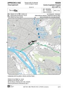
VAC chart of LFH179
 Satellite view of LFH179
Satellite view of LFH179
Sorry, we have no imagery here.
Sorry, we have no imagery here.
Sorry, we have no imagery here.
Sorry, we have no imagery here.
Sorry, we have no imagery here.
Sorry, we have no imagery here.


LFH179 - Rouen Centre Hospitalier
Located in , France
ICAO - , IATA -
Data provided by AirmateGeneral information
Coordinates: N49°26'26" E1°6'40"
Elevation is 144 feet MSL.
Magnetic variation is 0.61° East View others Airports in Upper Normandy
Operational data
Special qualification required
Current time UTC:
Current local time:
Weather at : LFOP - Rouen Vallee De Seine ( 8 km )
METAR: LFOP 111200Z AUTO 09006KT 010V150 CAVOK 17/06 Q1021 NOSIG
TAF: TAF LFOP 111100Z 1112/1121 09006KT CAVOK
Communications frequencies: [VIEW]
Runways:
Airport contact information
Address: France
Satellite view of LFH179
Sorry, we have no imagery here.
Sorry, we have no imagery here.
Sorry, we have no imagery here.
Sorry, we have no imagery here.
Sorry, we have no imagery here.
Sorry, we have no imagery here.