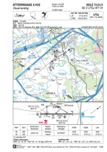
VAC chart of LFGJ
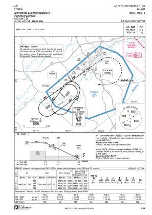
 IAC chart of LFGJ
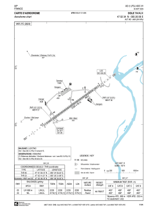
 ADC chart of LFGJ
 Satellite view of LFGJ
IAC chart of LFGJADC chart of LFGJ
Satellite view of LFGJ
Sorry, we have no imagery here.
Sorry, we have no imagery here.
Sorry, we have no imagery here.
Sorry, we have no imagery here.
Sorry, we have no imagery here.
Sorry, we have no imagery here.


LFGJ - Dole Tavaux
Located in Dole, France
ICAO - LFGJ, IATA - DLE
Data provided by AirmateGeneral information
Coordinates: N47°2'34" E5°26'6"
Elevation is 645 feet MSL.
Magnetic variation is 1.96° East View others Airports in Franche-Comté
Operational data
Special qualification required
Current time UTC:
Current local time:
Weather
METAR: LFGJ 111130Z AUTO VRB02KT CAVOK 20/03 Q1020 NOSIG
TAF: TAF LFGJ 111100Z 1112/1121 VRB04KT CAVOK
Communications frequencies: [VIEW]
Runways:
| RWY identifier | QFU | Length (ft) | Width (ft) | Surface | LDA (ft) |
| 05 | 54° | 7316 | 148 | MACADAM | 7316 |
| 23 | 234° | 7316 | 148 | MACADAM | 7136 |
Airport contact information
Address: Dole France
Handlers

Other aviation service providers
Aviation club (not for profit)

Satellite view of LFGJ
Sorry, we have no imagery here.
Sorry, we have no imagery here.
Sorry, we have no imagery here.
Sorry, we have no imagery here.
Sorry, we have no imagery here.
Sorry, we have no imagery here.