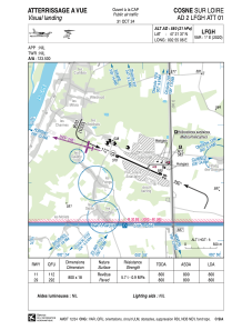
LFGH - Cosne Sur Loire
Located in Cosne, France
ICAO - LFGH, IATA -
Data provided by AirmateGeneral information
Coordinates: N47°21'37" E2°55'6"
Elevation is 580 feet MSL.
Magnetic variation is 1.26° East View others Airports in Burgundy
Operational data
Special qualification required
Current time UTC:
Current local time:
Weather at : LFOA - Avord ( 40 km )
METAR: LFOA 041030Z AUTO 12012KT 090V160 CAVOK 20/07 Q1014 NOSIG
TAF: TAF LFOA 040800Z 0409/0509 10010KT CAVOK TX23/0415Z TN09/0506Z
Communications frequencies: [VIEW]
Runways:
| RWY identifier | QFU | Length (ft) | Width (ft) | Surface | LDA (ft) |
| 11 | 114° | 2625 | 59 | ASPH | 2625 |
| 29 | 294° | 2625 | 59 | ASPH | 2625 |
Airport contact information
Address: Cosne France
Other aviation service providers
Aviation club (not for profit)
Satellite view of LFGH
Sorry, we have no imagery here.
Sorry, we have no imagery here.
Sorry, we have no imagery here.
Sorry, we have no imagery here.
Sorry, we have no imagery here.
Sorry, we have no imagery here.


