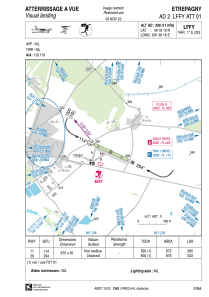
VAC chart of LFFY
 Satellite view of LFFY
Satellite view of LFFY
Sorry, we have no imagery here.
Sorry, we have no imagery here.
Sorry, we have no imagery here.
Sorry, we have no imagery here.
Sorry, we have no imagery here.
Sorry, we have no imagery here.


LFFY - Etrepagny
Located in Etrepagny, France
ICAO - LFFY, IATA -
Data provided by AirmateGeneral information
Coordinates: N49°18'19" E1°38'16"
Elevation is 308 feet MSL.
Magnetic variation is 0.78° East View others Airports in Upper Normandy
Operational data
Special qualification required
Current time UTC:
Current local time:
Weather at : LFOP - Rouen Vallee De Seine ( 34 km )
METAR: LFOP 100700Z AUTO 04010KT 8000 NSC 05/04 Q1029 TEMPO BKN005
TAF: TAF LFOP 100500Z 1006/1015 05007KT 7000 NSC PROB40 1006/1008 BKN005 TEMPO 1008/1010 BKN012 FM101000 04010KT 9999 SCT020
Communications frequencies: [VIEW]
Runways:
| RWY identifier | QFU | Length (ft) | Width (ft) | Surface | LDA (ft) |
| 11 | 115° | 2215 | 164 | GRASS | |
| 29 | 295° | 2215 | 164 | GRASS |
Airport contact information
Address: Etrepagny France
Other aviation service providers
Aviation club (not for profit)

Satellite view of LFFY
Sorry, we have no imagery here.
Sorry, we have no imagery here.
Sorry, we have no imagery here.
Sorry, we have no imagery here.
Sorry, we have no imagery here.
Sorry, we have no imagery here.