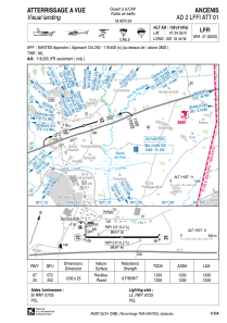
VAC chart of LFFI
 Satellite view of LFFI
Satellite view of LFFI
Sorry, we have no imagery here.
Sorry, we have no imagery here.
Sorry, we have no imagery here.
Sorry, we have no imagery here.
Sorry, we have no imagery here.
Sorry, we have no imagery here.


LFFI - Ancenis
Located in Ancenis, France
ICAO - LFFI, IATA -
Data provided by AirmateGeneral information
Coordinates: N47°24'26" W1°10'44"
Elevation is 109 feet MSL.
Magnetic variation is 0.03° East View others Airports in Pays-de-la-Loire
Operational data
Special qualification required
Current time UTC:
Current local time:
Weather at : LFRS - Nantes Atlantique ( 43 km )
METAR: LFRS 061330Z AUTO 02005KT 310V100 CAVOK 22/10 Q1015 NOSIG
TAF: TAF LFRS 061100Z 0612/0718 05005KT CAVOK
Communications frequencies: [VIEW]
Runways:
| RWY identifier | QFU | Length (ft) | Width (ft) | Surface | LDA (ft) |
| 07 | 72° | 3937 | 82 | ASPH | 3937 |
| 25 | 252° | 3937 | 82 | ASPH | 3937 |
Airport contact information
Address: Ancenis France
Handlers

Other aviation service providers
Aviation club (not for profit)

Satellite view of LFFI
Sorry, we have no imagery here.
Sorry, we have no imagery here.
Sorry, we have no imagery here.
Sorry, we have no imagery here.
Sorry, we have no imagery here.
Sorry, we have no imagery here.