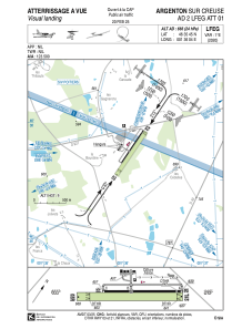
VAC chart of LFEG
 Satellite view of LFEG
Satellite view of LFEG
Sorry, we have no imagery here.
Sorry, we have no imagery here.
Sorry, we have no imagery here.
Sorry, we have no imagery here.
Sorry, we have no imagery here.
Sorry, we have no imagery here.


LFEG - Argenton Sur Creuse
Located in Argenton, France
ICAO - LFEG, IATA -
Data provided by AirmateGeneral information
Coordinates: N46°35'45" E1°36'4"
Elevation is 666 feet MSL.
Magnetic variation is 0.92° East View others Airports in Centre
Operational data
Special qualification required
Current time UTC:
Current local time:
Weather at : LFLX - Chateauroux Deols ( 31 km )
METAR: LFLX 101130Z AUTO 08013KT 040V100 CAVOK 19/03 Q1025 NOSIG
TAF: TAF LFLX 101100Z 1012/1118 05010KT CAVOK PROB30 TEMPO 1012/1016 07014G25KT
Communications frequencies: [VIEW]
Runways:
| RWY identifier | QFU | Length (ft) | Width (ft) | Surface | LDA (ft) |
| 04 | 34° | 2067 | 59 | ASPH | |
| 22 | 214° | 2067 | 59 | ASPH | |
| 04R | 34° | 2723 | 213 | GRASS | |
| 22L | 214° | 2723 | 213 | GRASS |
Airport contact information
Address: Argenton France
Other aviation service providers
Aviation club (not for profit)

Aviation medical examiner

Satellite view of LFEG
Sorry, we have no imagery here.
Sorry, we have no imagery here.
Sorry, we have no imagery here.
Sorry, we have no imagery here.
Sorry, we have no imagery here.
Sorry, we have no imagery here.