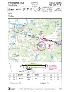
VAC chart of LFDS
 Satellite view of LFDS
Satellite view of LFDS
Sorry, we have no imagery here.
Sorry, we have no imagery here.
Sorry, we have no imagery here.
Sorry, we have no imagery here.
Sorry, we have no imagery here.
Sorry, we have no imagery here.


LFDS - Sarlat Domme
Located in Sarlat, France
ICAO - LFDS, IATA - XSL
Data provided by AirmateGeneral information
Coordinates: N44°47'32" E1°14'37"
Elevation is 979 feet MSL.
Magnetic variation is 0.89° East View others Airports in Aquitaine
Operational data
Special qualification required
Current time UTC:
Current local time:
Weather at : LFSL - Brive Souillac ( 33 km )
METAR: LFSL 022100Z AUTO 14012KT CAVOK 11/03 Q1010
TAF: TAF AMD LFSL 021542Z 0215/0224 15010KT 9999 BKN040 TEMPO 0215/0220 VRB15G25KT 4000 SHRA FEW025CB BKN030TCU
Communications frequencies: [VIEW]
Runways:
| RWY identifier | QFU | Length (ft) | Width (ft) | Surface | LDA (ft) |
| 10 | 104° | 2444 | 66 | ASPH | 2444 |
| 28 | 284° | 2444 | 66 | ASPH | 2444 |
Airport contact information
Address: Sarlat France
Fuel provider

Other aviation service providers
Aviation club (not for profit)

Aviation medical examiner

Satellite view of LFDS
Sorry, we have no imagery here.
Sorry, we have no imagery here.
Sorry, we have no imagery here.
Sorry, we have no imagery here.
Sorry, we have no imagery here.
Sorry, we have no imagery here.