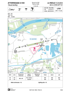
VAC chart of LFDR
 Satellite view of LFDR
Satellite view of LFDR
Sorry, we have no imagery here.
Sorry, we have no imagery here.
Sorry, we have no imagery here.
Sorry, we have no imagery here.
Sorry, we have no imagery here.
Sorry, we have no imagery here.


LFDR - La Reole Floudes
Located in La Reole, France
ICAO - LFDR, IATA -
Data provided by AirmateGeneral information
Coordinates: N44°34'1" W0°3'26"
Elevation is 44 feet MSL.
Magnetic variation is 0.54° East View others Airports in Aquitaine
Operational data
Special qualification required
Current time UTC:
Current local time:
Weather at : LFBE - Bergerac Dordogne Perigord ( 54 km )
METAR: LFBE 022000Z AUTO 07007KT CAVOK 09/08 Q1008 NOSIG
TAF: TAF LFBE 021100Z 0212/0312 12015KT 9999 BKN040 TEMPO 0212/0218 12018G30KT 4000 SHRA FEW025CB BKN030TCU PROB30 TEMPO 0212/0216 2000 TSRA BKN025CB TEMPO 0300/0312 12015G25KT
Communications frequencies: [VIEW]
Runways:
| RWY identifier | QFU | Length (ft) | Width (ft) | Surface | LDA (ft) |
| 08 | 78° | 3156 | 197 | GRASS | 3156 |
| 26 | 258° | 3156 | 197 | GRASS | 2552 |
Airport contact information
Address: La Reole France
Other aviation service providers
Aviation club (not for profit)

Satellite view of LFDR
Sorry, we have no imagery here.
Sorry, we have no imagery here.
Sorry, we have no imagery here.
Sorry, we have no imagery here.
Sorry, we have no imagery here.
Sorry, we have no imagery here.