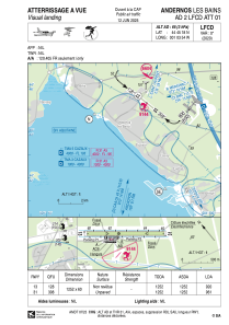
LFCD - Andernos Les Bains
Located in Andernos, France
ICAO - LFCD, IATA -
Data provided by AirmateGeneral information
Coordinates: N44°45'18" W1°3'54"
Elevation is 64 feet MSL.
Magnetic variation is 0.24° East View others Airports in Aquitaine
Operational data
Special qualification required
Current time UTC:
Current local time:
Weather at : LFBC - Cazaux ( 25 km )
METAR: LFBC 030400Z AUTO 15004KT CAVOK 11/09 Q1009
TAF: TAF LFBC 022000Z 0221/0321 12007KT CAVOK TEMPO 0300/0309 4900 -RA BECMG 0314/0316 23010KT TEMPO 0314/0316 4000 RA BECMG 0316/0318 VRB03KT
Communications frequencies: [VIEW]
Runways:
| RWY identifier | QFU | Length (ft) | Width (ft) | Surface | LDA (ft) |
| 13 | 128° | 4068 | 197 | GRASS | 2986 |
| 31 | 308° | 4068 | 197 | GRASS | 3150 |
Airport contact information
Address: Andernos France
Fuel provider
Other aviation service providers
Aviation club (not for profit)
HELI'S COOL Héliclub du Bassin d'Arcachon
HELI'S COOL Héliclub du Bassin d'Arcachon
info@heliscool.fr+33608714287
Aviation medical examiner
Satellite view of LFCD
Sorry, we have no imagery here.
Sorry, we have no imagery here.
Sorry, we have no imagery here.
Sorry, we have no imagery here.
Sorry, we have no imagery here.
Sorry, we have no imagery here.


