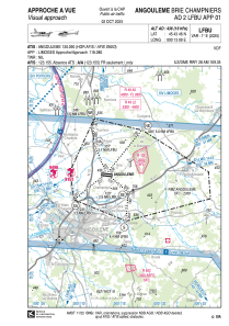
VAC chart of LFBU
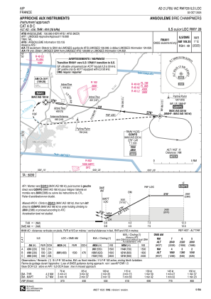
 IAC chart of LFBU
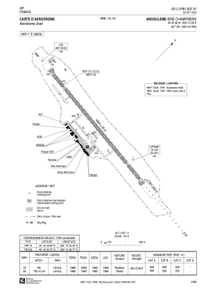
 ADC chart of LFBU
 Satellite view of LFBU
IAC chart of LFBUADC chart of LFBU
Satellite view of LFBU
Sorry, we have no imagery here.
Sorry, we have no imagery here.
Sorry, we have no imagery here.
Sorry, we have no imagery here.
Sorry, we have no imagery here.
Sorry, we have no imagery here.


LFBU - Angouleme Brie Champniers
Located in Angouleme, France
ICAO - LFBU, IATA - ANG
Data provided by AirmateGeneral information
Coordinates: N45°43'46" E0°13'9"
Elevation is 436 feet MSL.
Magnetic variation is 0.56° East View others Airports in Poitou-Charentes
Operational data
Special qualification required
Current time UTC:
Current local time:
Weather
METAR: LFBU 061330Z AUTO 02010KT 350V050 CAVOK 23/07 Q1014 NOSIG
TAF: TAF LFBU 061100Z 0612/0712 33010KT CAVOK BECMG 0700/0702 04005KT
Communications frequencies: [VIEW]
Runways:
| RWY identifier | QFU | Length (ft) | Width (ft) | Surface | LDA (ft) |
| 10 | 97° | 6102 | 148 | ASPH | 6102 |
| 28 | 277° | 6102 | 148 | ASPH | 6102 |
Airport contact information
Address: Angouleme France
Other aviation service providers
Aviation club (not for profit)

Satellite view of LFBU
Sorry, we have no imagery here.
Sorry, we have no imagery here.
Sorry, we have no imagery here.
Sorry, we have no imagery here.
Sorry, we have no imagery here.
Sorry, we have no imagery here.