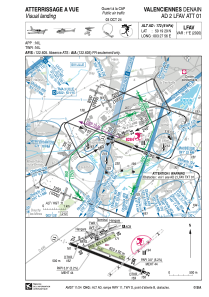
VAC chart of LFAV
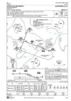
 IAC chart of LFAV
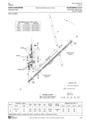
 ADC chart of LFAV
 Satellite view of LFAV
IAC chart of LFAVADC chart of LFAV
Satellite view of LFAV
Sorry, we have no imagery here.
Sorry, we have no imagery here.
Sorry, we have no imagery here.
Sorry, we have no imagery here.
Sorry, we have no imagery here.
Sorry, we have no imagery here.


LFAV - Valenciennes Denain
Located in Valenciennes, France
ICAO - LFAV, IATA - XVS
Data provided by AirmateGeneral information
Coordinates: N50°19'29" E3°27'56"
Elevation is 172 feet MSL.
Magnetic variation is 1.29° East View others Airports in Nord-Pas-de-Calais
Operational data
Special qualification required
Current time UTC:
Current local time:
Communications frequencies: [VIEW]
Runways:
| RWY identifier | QFU | Length (ft) | Width (ft) | Surface | LDA (ft) |
| 11 | 111° | 5604 | 148 | ASPH | 4964 |
| 29 | 291° | 5604 | 148 | ASPH | 5223 |
| 06 | 61° | 2051 | 164 | GRASS | |
| 24 | 241° | 2051 | 164 | GRASS | |
| 11L | 111° | 2034 | 164 | GRASS | |
| 29R | 291° | 2034 | 164 | GRASS |
Airport contact information
Address: Valenciennes France
Handlers

Other aviation service providers
Aviation club (not for profit)

Aviation medical examiner

Satellite view of LFAV
Sorry, we have no imagery here.
Sorry, we have no imagery here.
Sorry, we have no imagery here.
Sorry, we have no imagery here.
Sorry, we have no imagery here.
Sorry, we have no imagery here.