VAC chart of LFAS
 Satellite view of LFAS
Satellite view of LFAS
Sorry, we have no imagery here.
Sorry, we have no imagery here.
Sorry, we have no imagery here.
Sorry, we have no imagery here.
Sorry, we have no imagery here.
Sorry, we have no imagery here.


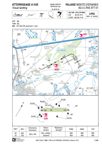
LFAS - Falaise Monts D'eraines
Located in , France
ICAO - LFAS, IATA -
Data provided by AirmateGeneral information
Coordinates: N48°55'37" W0°8'41"
Elevation is 513 feet MSL.
Magnetic variation is 0.24° East View others Airports in Lower Normandy
Operational data
Special qualification required
Current time UTC:
Current local time:
Weather at : LFRK - Caen Carpiquet ( 35 km )
METAR: LFRK 060830Z AUTO 03006KT 360V060 CAVOK 11/05 Q1019 NOSIG
TAF: TAF LFRK 060800Z 0609/0618 VRB05KT CAVOK BECMG 0611/0613 04010KT
Communications frequencies: [VIEW]
Runways:
| RWY identifier | QFU | Length (ft) | Width (ft) | Surface | LDA (ft) |
| 06 | 62° | 2789 | 328 | GRASS | 2789 |
| 24 | 242° | 2789 | 328 | GRASS | 2789 |
Airport contact information
Address: France
Other aviation service providers
Aviation club (not for profit)

Aviation medical examiner

Satellite view of LFAS
Sorry, we have no imagery here.
Sorry, we have no imagery here.
Sorry, we have no imagery here.
Sorry, we have no imagery here.
Sorry, we have no imagery here.
Sorry, we have no imagery here.