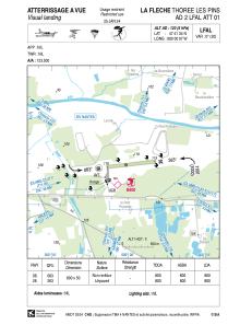
VAC chart of LFAL
 Satellite view of LFAL
Satellite view of LFAL
Sorry, we have no imagery here.
Sorry, we have no imagery here.
Sorry, we have no imagery here.
Sorry, we have no imagery here.
Sorry, we have no imagery here.
Sorry, we have no imagery here.


LFAL - La Fleche Thoree Les Pins
Located in , France
ICAO - LFAL, IATA -
Data provided by AirmateGeneral information
Coordinates: N47°41'34" W0°0'7"
Elevation is 120 feet MSL.
Magnetic variation is 0.38° East View others Airports in Pays-de-la-Loire
Operational data
Special qualification required
Current time UTC:
Current local time:
Weather at : LFJR - Angers Marce ( 28 km )
METAR: LFJR 061030Z AUTO VRB03KT CAVOK 18/09 Q1016
Communications frequencies: [VIEW]
Runways:
| RWY identifier | QFU | Length (ft) | Width (ft) | Surface | LDA (ft) |
| 08 | 83° | 2625 | 164 | GRASS | 3724 |
| 26 | 263° | 2625 | 164 | GRASS | 4708 |
Airport contact information
Address: France
Other aviation service providers
Aviation club (not for profit)

Aviation medical examiner

Satellite view of LFAL
Sorry, we have no imagery here.
Sorry, we have no imagery here.
Sorry, we have no imagery here.
Sorry, we have no imagery here.
Sorry, we have no imagery here.
Sorry, we have no imagery here.