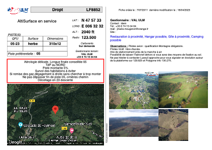
LF8852 - Dropt
Located in Girmont-Val-d'Ajol, France
ICAO - , IATA -
Data provided by AirmateGeneral information
Coordinates: N47°57'33" E6°32'32"
Elevation is 2040 feet MSL.
View others Airports in Lorraine
Operational data
Special qualification required
Current time UTC:
Current local time:
Weather at : LFSX - Luxeuil Saint Sauveur ( 23 km )
METAR: LFSX 031000Z AUTO 15005KT 080V190 CAVOK 17/07 Q1021
TAF: TAF LFSX 030800Z 0309/0409 13008KT CAVOK PROB30 TEMPO 0403/0406 3000 BR
Communications frequencies: [VIEW]
Runways:
| RWY identifier | QFU | Length (ft) | Width (ft) | Surface | LDA (ft) |
| 05 | 0° | 1017 | 39 | GRASS | |
| 23 | 0° | 1017 | 39 | GRASS |
Airport contact information
Address: Girmont-Val-d'Ajol France
Satellite view of LF8852
Sorry, we have no imagery here.
Sorry, we have no imagery here.
Sorry, we have no imagery here.
Sorry, we have no imagery here.
Sorry, we have no imagery here.
Sorry, we have no imagery here.


