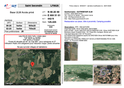
VAC chart of LF8626
 Satellite view of LF8626
Satellite view of LF8626
Sorry, we have no imagery here.
Sorry, we have no imagery here.
Sorry, we have no imagery here.
Sorry, we have no imagery here.
Sorry, we have no imagery here.
Sorry, we have no imagery here.


LF8626 - Saint Secondin
Located in Saint-Secondin, France
ICAO - , IATA -
Data provided by AirmateGeneral information
Coordinates: N46°20'49" E0°31'1"
Elevation is 443 feet MSL.
View others Airports in Poitou-Charentes
Operational data
Special qualification required
Current time UTC:
Current local time:
Weather at : LFBI - Poitiers Biard ( 31 km )
METAR: LFBI 070200Z AUTO 35004KT CAVOK 07/02 Q1018 NOSIG
TAF: TAF LFBI 062300Z 0700/0724 01006KT CAVOK
Communications frequencies: [VIEW]
Runways:
| RWY identifier | QFU | Length (ft) | Width (ft) | Surface | LDA (ft) |
| 08 | 0° | 1968 | 65 | GRASS | |
| 26 | 0° | 1968 | 65 | GRASS |
Airport contact information
Address: Saint-Secondin France
Satellite view of LF8626
Sorry, we have no imagery here.
Sorry, we have no imagery here.
Sorry, we have no imagery here.
Sorry, we have no imagery here.
Sorry, we have no imagery here.
Sorry, we have no imagery here.