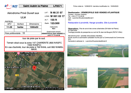
VAC chart of LF8571
 Satellite view of LF8571
Satellite view of LF8571
Sorry, we have no imagery here.
Sorry, we have no imagery here.
Sorry, we have no imagery here.
Sorry, we have no imagery here.
Sorry, we have no imagery here.
Sorry, we have no imagery here.


LF8571 - Saint Aubin la Plaine
Located in Saint-Aubin-la-Plaine, France
ICAO - , IATA -
Data provided by AirmateGeneral information
Coordinates: N46°31'7" W1°3'17"
Elevation is 155 feet MSL.
View others Airports in Upper Normandy
Operational data
Special qualification required
Current time UTC:
Current local time:
Weather at : LFRI - La Roche Sur Yon Les Ajoncs ( 32 km )
METAR: LFRI 101730Z AUTO 06015KT CAVOK 19/05 Q1022 NOSIG
TAF: TAF LFRI 101100Z 1012/1112 06012KT CAVOK
Communications frequencies: [VIEW]
Runways:
| RWY identifier | QFU | Length (ft) | Width (ft) | Surface | LDA (ft) |
| 11 | 0° | 3280 | 164 | GRASS | |
| 29 | 0° | 3280 | 164 | GRASS |
Airport contact information
Address: Saint-Aubin-la-Plaine France
Satellite view of LF8571
Sorry, we have no imagery here.
Sorry, we have no imagery here.
Sorry, we have no imagery here.
Sorry, we have no imagery here.
Sorry, we have no imagery here.
Sorry, we have no imagery here.