VAC chart of LF8529
 Satellite view of LF8529
Satellite view of LF8529
Sorry, we have no imagery here.
Sorry, we have no imagery here.
Sorry, we have no imagery here.
Sorry, we have no imagery here.
Sorry, we have no imagery here.
Sorry, we have no imagery here.


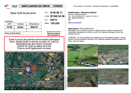
LF8529 - Saint Laurent sur Sèvre
Located in Saint-Laurent-sur-Sèvre , France
ICAO - , IATA -
Data provided by AirmateGeneral information
Coordinates: N46°56'17" W0°54'56"
Elevation is 643 feet MSL.
View others Airports in Poitou-Charentes
Operational data
Special qualification required
Current time UTC:
Current local time:
Communications frequencies: [VIEW]
Runways:
| RWY identifier | QFU | Length (ft) | Width (ft) | Surface | LDA (ft) |
| 10 | 0° | 1279 | 32 | GRASS | |
| 28 | 0° | 1279 | 32 | GRASS |
Airport contact information
Address: Saint-Laurent-sur-Sèvre France
Satellite view of LF8529
Sorry, we have no imagery here.
Sorry, we have no imagery here.
Sorry, we have no imagery here.
Sorry, we have no imagery here.
Sorry, we have no imagery here.
Sorry, we have no imagery here.