VAC chart of LF8021
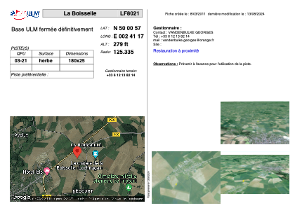 Satellite view of LF8021

Satellite view of LF8021
Sorry, we have no imagery here.
Sorry, we have no imagery here.
Sorry, we have no imagery here.
Sorry, we have no imagery here.
Sorry, we have no imagery here.
Sorry, we have no imagery here.


LF8021 - La Boisselle
Located in Ovillers-La-Boisselle, France
ICAO - , IATA -
Data provided by AirmateGeneral information
Coordinates: N50°0'57" E2°41'17"
Elevation is 279 feet MSL.
View others Airports in Picardie
Operational data
Special qualification required
Current time UTC:
Current local time:
Weather at : LFAQ - Albert Bray ( 5 km )
METAR: LFAQ 181800Z AUTO 03010KT CAVOK 24/14 Q1016
TAF: TAF LFAQ 181400Z 1815/1824 07010KT CAVOK
Communications frequencies: [VIEW]
Runways:
Airport contact information
Address: Ovillers-La-Boisselle France
Satellite view of LF8021
Sorry, we have no imagery here.
Sorry, we have no imagery here.
Sorry, we have no imagery here.
Sorry, we have no imagery here.
Sorry, we have no imagery here.
Sorry, we have no imagery here.