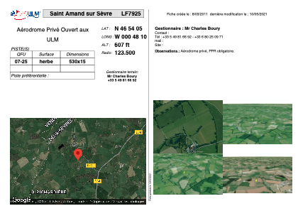
VAC chart of LF7925
 Satellite view of LF7925
Satellite view of LF7925
Sorry, we have no imagery here.
Sorry, we have no imagery here.
Sorry, we have no imagery here.
Sorry, we have no imagery here.
Sorry, we have no imagery here.
Sorry, we have no imagery here.


LF7925 - Saint Amand sur Sèvre
Located in Saint-Amand-sur-Sèvre, France
ICAO - , IATA -
Data provided by AirmateGeneral information
Coordinates: N46°54'5" W0°48'10"
Elevation is 607 feet MSL.
View others Airports in Poitou-Charentes
Operational data
Special qualification required
Current time UTC:
Current local time:
Weather at : LFRI - La Roche Sur Yon Les Ajoncs ( 49 km )
METAR: LFRI 061030Z AUTO 35005KT 320V020 CAVOK 16/13 Q1016 NOSIG
TAF: TAF AMD LFRI 060922Z 0609/0706 32004KT 7000 BKN005 BECMG 0609/0610 CAVOK
Communications frequencies: [VIEW]
Runways:
| RWY identifier | QFU | Length (ft) | Width (ft) | Surface | LDA (ft) |
| 07 | 0° | 1738 | 49 | GRASS | |
| 25 | 0° | 1738 | 49 | GRASS |
Airport contact information
Address: Saint-Amand-sur-Sèvre France
Satellite view of LF7925
Sorry, we have no imagery here.
Sorry, we have no imagery here.
Sorry, we have no imagery here.
Sorry, we have no imagery here.
Sorry, we have no imagery here.
Sorry, we have no imagery here.