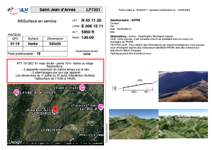
VAC chart of LF7331
 Satellite view of LF7331
Satellite view of LF7331
Sorry, we have no imagery here.
Sorry, we have no imagery here.
Sorry, we have no imagery here.
Sorry, we have no imagery here.
Sorry, we have no imagery here.
Sorry, we have no imagery here.


LF7331 - Saint Jean d'Arves
Located in Saint-Jean-d'Arves, France
ICAO - , IATA -
Data provided by AirmateGeneral information
Coordinates: N45°11'20" E6°15'11"
Elevation is 5950 feet MSL.
View others Airports in Rhône Alpes
Operational data
Special qualification required
Current time UTC:
Current local time:
Weather at : LFLB - Chambery Aix Les Bains ( 58 km )
METAR: LFLB 092330Z AUTO 16003KT 110V180 7000 NSC 06/06 Q1021
TAF: TAF LFLB 091400Z 0915/1015 36008KT CAVOK PROB40 TEMPO 0915/0918 SHRA SCT045TCU PROB30 TEMPO 0915/0918 VRB15G25KT 4000 TSRA SCT040CB
Communications frequencies: [VIEW]
Runways:
| RWY identifier | QFU | Length (ft) | Width (ft) | Surface | LDA (ft) |
| 01 | 0° | 1082 | 164 | GRASS | |
| 19 | 0° | 1082 | 164 | GRASS |
Airport contact information
Address: Saint-Jean-d'Arves France
Satellite view of LF7331
Sorry, we have no imagery here.
Sorry, we have no imagery here.
Sorry, we have no imagery here.
Sorry, we have no imagery here.
Sorry, we have no imagery here.
Sorry, we have no imagery here.