VAC chart of LF7029
 Satellite view of LF7029
Satellite view of LF7029
Sorry, we have no imagery here.
Sorry, we have no imagery here.
Sorry, we have no imagery here.
Sorry, we have no imagery here.
Sorry, we have no imagery here.
Sorry, we have no imagery here.


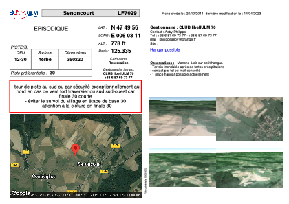
LF7029 - Senoncourt
Located in Senoncourt, France
ICAO - , IATA -
Data provided by AirmateGeneral information
Coordinates: N47°49'56" E6°3'11"
Elevation is 778 feet MSL.
View others Airports in Franche-Comté
Operational data
Special qualification required
Current time UTC:
Current local time:
Weather at : LFSX - Luxeuil Saint Sauveur ( 24 km )
TAF: TAF LFSX 090800Z 0909/1009 25003KT CAVOK BECMG 0914/0916 02010KT
Communications frequencies: [VIEW]
Runways:
| RWY identifier | QFU | Length (ft) | Width (ft) | Surface | LDA (ft) |
| 12 | 0° | 1148 | 65 | GRASS | |
| 30 | 0° | 1148 | 65 | GRASS |
Airport contact information
Address: Senoncourt France
Satellite view of LF7029
Sorry, we have no imagery here.
Sorry, we have no imagery here.
Sorry, we have no imagery here.
Sorry, we have no imagery here.
Sorry, we have no imagery here.
Sorry, we have no imagery here.