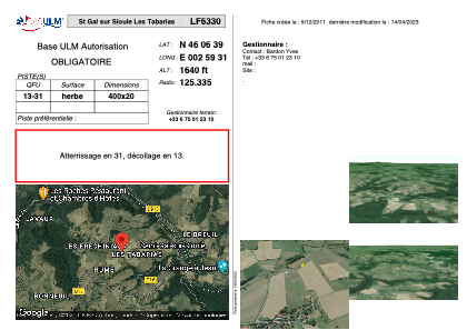
VAC chart of LF6330
 Satellite view of LF6330
Satellite view of LF6330
Sorry, we have no imagery here.
Sorry, we have no imagery here.
Sorry, we have no imagery here.
Sorry, we have no imagery here.
Sorry, we have no imagery here.
Sorry, we have no imagery here.


LF6330 - St Gal sur Sioule Les Tabarias
Located in Saint-Gal-sur-Sioule, France
ICAO - , IATA -
Data provided by AirmateGeneral information
Coordinates: N46°6'39" E2°59'31"
Elevation is 1640 feet MSL.
View others Airports in Limousin
Operational data
Special qualification required
Current time UTC:
Current local time:
Weather at : LFLV - Vichy Charmeil ( 32 km )
METAR: LFLV 131400Z AUTO 17009KT 140V200 9999 FEW023 SCT032 BKN052 18/12 Q1009
Communications frequencies: [VIEW]
Runways:
| RWY identifier | QFU | Length (ft) | Width (ft) | Surface | LDA (ft) |
| 13 | 0° | 1312 | 65 | GRASS | |
| 31 | 0° | 1312 | 65 | GRASS |
Airport contact information
Address: Saint-Gal-sur-Sioule France
Satellite view of LF6330
Sorry, we have no imagery here.
Sorry, we have no imagery here.
Sorry, we have no imagery here.
Sorry, we have no imagery here.
Sorry, we have no imagery here.
Sorry, we have no imagery here.