VAC chart of LF6153
Satellite view of LF6153
Sorry, we have no imagery here.
To navigate, press the arrow keys.
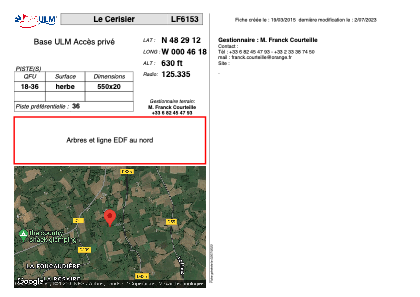
LF6153 - Le Cerisier
Located in Passais villages, France
ICAO - , IATA -
Data provided by
Airmate
General information
Coordinates:
N48°29'12" W0°46'18"
Elevation is
630 feet MSL.
Add your vote
Valid your vote
View others
Airports in
Pays-de-la-Loire
Operational data
Special qualification required
Current time UTC:
Current local time:
Weather at :
LFOV - Laval Entrammes
( 51 km )
METAR:
LFOV 071900Z AUTO 07003KT CAVOK 16/02 Q1022
View NOTAMs / SUP AIP / TFR affecting this airport
[VIEW]
Communications frequencies:
[VIEW]
Runways:
RWY identifier
QFU
Length
(ft)
Width
(ft)
Surface
LDA
(ft)
18
0°
1804
65
GRASS
36
0°
1804
65
GRASS
Airport contact information
Address:
Passais villages France
Satellite view of LF6153
Sorry, we have no imagery here.
To navigate, press the arrow keys.
<<
BESbswy
BESbswy