VAC chart of LF6025
 Satellite view of LF6025
Satellite view of LF6025
Sorry, we have no imagery here.
Sorry, we have no imagery here.
Sorry, we have no imagery here.
Sorry, we have no imagery here.
Sorry, we have no imagery here.
Sorry, we have no imagery here.


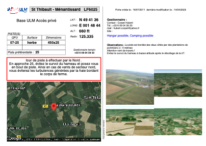
LF6025 - St Thibault - Ménantissard
Located in Saint-Thibault, France
ICAO - , IATA -
Data provided by AirmateGeneral information
Coordinates: N49°41'36" E1°48'44"
Elevation is 660 feet MSL.
View others Airports in Upper Normandy
Operational data
Special qualification required
Current time UTC:
Current local time:
Weather at : LFOB - Beauvais Tille ( 34 km )
METAR: LFOB 102230Z AUTO 02006KT CAVOK 06/04 Q1026 NOSIG
TAF: TAF LFOB 101700Z 1018/1118 02008KT CAVOK TEMPO 1103/1108 VRB03KT 3000 BR PROB40 TEMPO 1104/1107 0600 FG VV/// BECMG 1108/1110 08007KT
Communications frequencies: [VIEW]
Runways:
| RWY identifier | QFU | Length (ft) | Width (ft) | Surface | LDA (ft) |
| 07 | 0° | 1476 | 82 | GRASS | |
| 25 | 0° | 1476 | 82 | GRASS |
Airport contact information
Address: Saint-Thibault France
Satellite view of LF6025
Sorry, we have no imagery here.
Sorry, we have no imagery here.
Sorry, we have no imagery here.
Sorry, we have no imagery here.
Sorry, we have no imagery here.
Sorry, we have no imagery here.