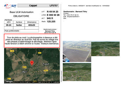
VAC chart of LF5757
 Satellite view of LF5757

Satellite view of LF5757
Sorry, we have no imagery here.
Sorry, we have no imagery here.
Sorry, we have no imagery here.
Sorry, we have no imagery here.
Sorry, we have no imagery here.
Sorry, we have no imagery here.


LF5757 - Cappel
Located in Cappel, France
ICAO - , IATA -
Data provided by AirmateGeneral information
Coordinates: N49°4'25" E6°50'28"
Elevation is 945 feet MSL.
View others Airports in Lorraine
Operational data
Special qualification required
Current time UTC:
Current local time:
Weather at : EDDR - Saarbruecken ( 25 km )
METAR: EDDR 022020Z AUTO 07011KT 040V100 CAVOK 12/03 Q1018 NOSIG
TAF: TAF EDDR 021700Z 0218/0318 08015G30KT CAVOK BECMG 0218/0221 07011KT
Communications frequencies: [VIEW]
Runways:
| RWY identifier | QFU | Length (ft) | Width (ft) | Surface | LDA (ft) |
| 06 | 0° | 1312 | 98 | GRASS | |
| 24 | 0° | 1312 | 98 | GRASS |
Airport contact information
Address: Cappel France
Satellite view of LF5757
Sorry, we have no imagery here.
Sorry, we have no imagery here.
Sorry, we have no imagery here.
Sorry, we have no imagery here.
Sorry, we have no imagery here.
Sorry, we have no imagery here.