VAC chart of LF5753
 Satellite view of LF5753
Satellite view of LF5753
Sorry, we have no imagery here.
Sorry, we have no imagery here.
Sorry, we have no imagery here.
Sorry, we have no imagery here.
Sorry, we have no imagery here.
Sorry, we have no imagery here.


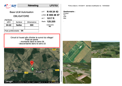
LF5753 - Rémeling
Located in Rémeling, France
ICAO - , IATA -
Data provided by AirmateGeneral information
Coordinates: N49°24'43" E6°28'37"
Elevation is 1017 feet MSL.
View others Airports in Lorraine
Operational data
Special qualification required
Current time UTC:
Current local time:
Weather at : ELLX - Luxembourg ( 31 km )
METAR: ELLX 021950Z 08008KT CAVOK 13/02 Q1018 NOSIG
TAF: TAF ELLX 021700Z 0218/0324 09015G25KT CAVOK BECMG 0218/0220 09009KT
Communications frequencies: [VIEW]
Runways:
| RWY identifier | QFU | Length (ft) | Width (ft) | Surface | LDA (ft) |
| 04 | 0° | 984 | 0 | GRASS | |
| 22 | 0° | 984 | 0 | GRASS |
Airport contact information
Address: Rémeling France
Satellite view of LF5753
Sorry, we have no imagery here.
Sorry, we have no imagery here.
Sorry, we have no imagery here.
Sorry, we have no imagery here.
Sorry, we have no imagery here.
Sorry, we have no imagery here.