VAC chart of LF5353
 Satellite view of LF5353
Satellite view of LF5353
Sorry, we have no imagery here.
Sorry, we have no imagery here.
Sorry, we have no imagery here.
Sorry, we have no imagery here.
Sorry, we have no imagery here.
Sorry, we have no imagery here.


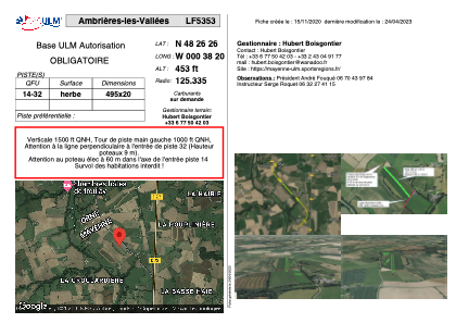
LF5353 - Ambrières-les-Vallées
Located in Ambrières-les-Vallées, France
ICAO - , IATA -
Data provided by AirmateGeneral information
Coordinates: N48°26'27" W0°38'20"
Elevation is 453 feet MSL.
View others Airports in Pays-de-la-Loire
Operational data
Special qualification required
Current time UTC:
Current local time:
Weather at : LFOV - Laval Entrammes ( 46 km )
METAR: LFOV 080830Z AUTO VRB03KT CAVOK 12/04 Q1025
Communications frequencies: [VIEW]
Runways:
| RWY identifier | QFU | Length (ft) | Width (ft) | Surface | LDA (ft) |
| 14 | 0° | 1624 | 65 | GRASS | |
| 32 | 0° | 1624 | 65 | GRASS |
Airport contact information
Address: Ambrières-les-Vallées France
Satellite view of LF5353
Sorry, we have no imagery here.
Sorry, we have no imagery here.
Sorry, we have no imagery here.
Sorry, we have no imagery here.
Sorry, we have no imagery here.
Sorry, we have no imagery here.