VAC chart of LF5323
 Satellite view of LF5323
Satellite view of LF5323
Sorry, we have no imagery here.
Sorry, we have no imagery here.
Sorry, we have no imagery here.
Sorry, we have no imagery here.
Sorry, we have no imagery here.
Sorry, we have no imagery here.


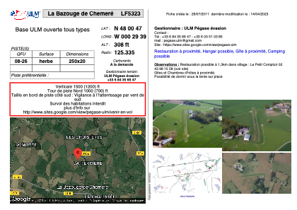
LF5323 - La Bazouge de Chemeré
Located in La-Bazouge-de-Chemeré, France
ICAO - , IATA -
Data provided by AirmateGeneral information
Coordinates: N48°0'47" W0°29'39"
Elevation is 308 feet MSL.
View others Airports in Pays-de-la-Loire
Operational data
Special qualification required
Current time UTC:
Current local time:
Weather at : LFOV - Laval Entrammes ( 19 km )
METAR: LFOV 061600Z AUTO 06006KT 020V110 CAVOK 21/08 Q1016
Communications frequencies: [VIEW]
Runways:
| RWY identifier | QFU | Length (ft) | Width (ft) | Surface | LDA (ft) |
| 08 | 0° | 820 | 65 | GRASS | |
| 26 | 0° | 820 | 65 | GRASS |
Airport contact information
Address: La-Bazouge-de-Chemeré France
Satellite view of LF5323
Sorry, we have no imagery here.
Sorry, we have no imagery here.
Sorry, we have no imagery here.
Sorry, we have no imagery here.
Sorry, we have no imagery here.
Sorry, we have no imagery here.