VAC chart of LF5321
 Satellite view of LF5321
Satellite view of LF5321
Sorry, we have no imagery here.
Sorry, we have no imagery here.
Sorry, we have no imagery here.
Sorry, we have no imagery here.
Sorry, we have no imagery here.
Sorry, we have no imagery here.


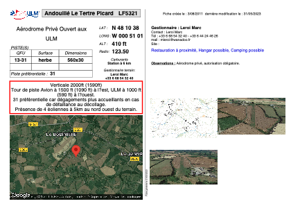
LF5321 - Andouillé Le Tertre Picard
Located in Andouillé, France
ICAO - , IATA -
Data provided by AirmateGeneral information
Coordinates: N48°10'38" W0°51'1"
Elevation is 410 feet MSL.
View others Airports in Pays-de-la-Loire
Operational data
Special qualification required
Current time UTC:
Current local time:
Weather at : LFOV - Laval Entrammes ( 18 km )
METAR: LFOV 081000Z AUTO 06005KT 030V100 CAVOK 16/04 Q1024
Communications frequencies: [VIEW]
Runways:
| RWY identifier | QFU | Length (ft) | Width (ft) | Surface | LDA (ft) |
| 13 | 0° | 1837 | 98 | GRASS | |
| 31 | 0° | 1837 | 98 | GRASS |
Airport contact information
Address: Andouillé France
Satellite view of LF5321
Sorry, we have no imagery here.
Sorry, we have no imagery here.
Sorry, we have no imagery here.
Sorry, we have no imagery here.
Sorry, we have no imagery here.
Sorry, we have no imagery here.