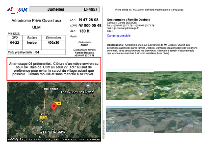
VAC chart of LF4957
 Satellite view of LF4957
Satellite view of LF4957
Sorry, we have no imagery here.
Sorry, we have no imagery here.
Sorry, we have no imagery here.
Sorry, we have no imagery here.
Sorry, we have no imagery here.
Sorry, we have no imagery here.


LF4957 - Jumelles
Located in Jumelles, France
ICAO - , IATA -
Data provided by AirmateGeneral information
Coordinates: N47°26'8" W0°5'48"
Elevation is 130 feet MSL.
View others Airports in Pays-de-la-Loire
Operational data
Special qualification required
Current time UTC:
Current local time:
Weather at : LFJR - Angers Marce ( 21 km )
METAR: LFJR 071200Z AUTO 09006KT 350V160 CAVOK 18/01 Q1021
Communications frequencies: [VIEW]
Runways:
| RWY identifier | QFU | Length (ft) | Width (ft) | Surface | LDA (ft) |
| 04 | 0° | 1312 | 98 | GRASS | |
| 22 | 0° | 1312 | 98 | GRASS |
Airport contact information
Address: Jumelles France
Satellite view of LF4957
Sorry, we have no imagery here.
Sorry, we have no imagery here.
Sorry, we have no imagery here.
Sorry, we have no imagery here.
Sorry, we have no imagery here.
Sorry, we have no imagery here.