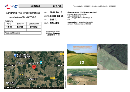
VAC chart of LF4725
 Satellite view of LF4725
Satellite view of LF4725
Sorry, we have no imagery here.
Sorry, we have no imagery here.
Sorry, we have no imagery here.
Sorry, we have no imagery here.
Sorry, we have no imagery here.
Sorry, we have no imagery here.


LF4725 - Sembas
Located in Sembas, France
ICAO - , IATA -
Data provided by AirmateGeneral information
Coordinates: N44°20'15" E0°38'58"
Elevation is 787 feet MSL.
View others Airports in Aquitaine
Operational data
Special qualification required
Current time UTC:
Current local time:
Weather at : LFBA - Agen La Garenne ( 19 km )
METAR: LFBA 022300Z AUTO 13011KT 9999 //////CB 13/06 Q1009
TAF: TAF LFBA 021400Z 0215/0224 11010KT 9999 SCT040 BKN060 PROB40 TEMPO 0215/0219 12015G25KT
Communications frequencies: [VIEW]
Runways:
| RWY identifier | QFU | Length (ft) | Width (ft) | Surface | LDA (ft) |
| 13 | 0° | 1640 | 39 | GRASS | |
| 31 | 0° | 1640 | 39 | GRASS |
Airport contact information
Address: Sembas France
Satellite view of LF4725
Sorry, we have no imagery here.
Sorry, we have no imagery here.
Sorry, we have no imagery here.
Sorry, we have no imagery here.
Sorry, we have no imagery here.
Sorry, we have no imagery here.