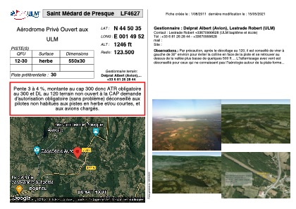
VAC chart of LF4627
 Satellite view of LF4627
Satellite view of LF4627
Sorry, we have no imagery here.
Sorry, we have no imagery here.
Sorry, we have no imagery here.
Sorry, we have no imagery here.
Sorry, we have no imagery here.
Sorry, we have no imagery here.


LF4627 - Saint Médard de Presque
Located in Saint-Médard-de-Presque, France
ICAO - , IATA -
Data provided by AirmateGeneral information
Coordinates: N44°50'35" E1°49'52"
Elevation is 1246 feet MSL.
View others Airports in Midi-Pyrénées
Operational data
Special qualification required
Current time UTC:
Current local time:
Weather at : LFSL - Brive Souillac ( 35 km )
METAR: LFSL 101630Z AUTO 02004KT 330V080 CAVOK 24/00 Q1019 NOSIG
TAF: TAF LFSL 101400Z 1015/1024 07008KT CAVOK
Communications frequencies: [VIEW]
Runways:
| RWY identifier | QFU | Length (ft) | Width (ft) | Surface | LDA (ft) |
| 12 | 0° | 1804 | 98 | GRASS | |
| 30 | 0° | 1804 | 98 | GRASS |
Airport contact information
Address: Saint-Médard-de-Presque France
Satellite view of LF4627
Sorry, we have no imagery here.
Sorry, we have no imagery here.
Sorry, we have no imagery here.
Sorry, we have no imagery here.
Sorry, we have no imagery here.
Sorry, we have no imagery here.