VAC chart of LF4559
 Satellite view of LF4559
Satellite view of LF4559
Sorry, we have no imagery here.
Sorry, we have no imagery here.
Sorry, we have no imagery here.
Sorry, we have no imagery here.
Sorry, we have no imagery here.
Sorry, we have no imagery here.


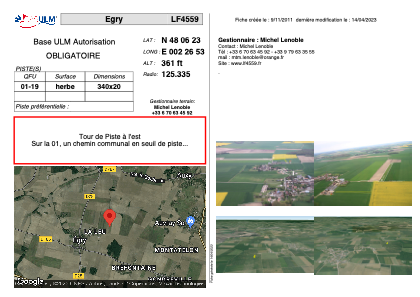
LF4559 - Egry
Located in Egry, France
ICAO - , IATA -
Data provided by AirmateGeneral information
Coordinates: N48°6'23" E2°26'53"
Elevation is 361 feet MSL.
View others Airports in Centre
Operational data
Special qualification required
Current time UTC:
Current local time:
Weather at : LFOZ - Orleans Saint Denis De L'hotel ( 31 km )
METAR: LFOZ 100700Z AUTO 04011KT 9999 4600 NSC 08/05 Q1027
Communications frequencies: [VIEW]
Runways:
| RWY identifier | QFU | Length (ft) | Width (ft) | Surface | LDA (ft) |
| 01 | 0° | 1115 | 65 | GRASS | |
| 19 | 0° | 1115 | 65 | GRASS |
Airport contact information
Address: Egry France
Web: www.lf4559.fr
Satellite view of LF4559
Sorry, we have no imagery here.
Sorry, we have no imagery here.
Sorry, we have no imagery here.
Sorry, we have no imagery here.
Sorry, we have no imagery here.
Sorry, we have no imagery here.