VAC chart of LF4321
 Satellite view of LF4321
Satellite view of LF4321
Sorry, we have no imagery here.
Sorry, we have no imagery here.
Sorry, we have no imagery here.
Sorry, we have no imagery here.
Sorry, we have no imagery here.
Sorry, we have no imagery here.


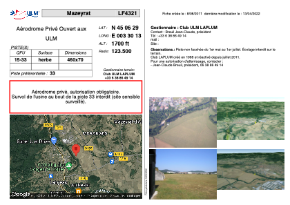
LF4321 - Mazeyrat
Located in Mazeyrat-d'Allier, France
ICAO - , IATA -
Data provided by AirmateGeneral information
Coordinates: N45°6'29" E3°30'13"
Elevation is 1700 feet MSL.
View others Airports in Auvergne
Operational data
Special qualification required
Current time UTC:
Current local time:
Weather at : LFHP - Le Puy Loudes ( 21 km )
METAR: LFHP 081230Z AUTO 08004KT 030V160 CAVOK 17/M02 Q1022
Communications frequencies: [VIEW]
Runways:
| RWY identifier | QFU | Length (ft) | Width (ft) | Surface | LDA (ft) |
| 15 | 0° | 1509 | 229 | GRASS | |
| 33 | 0° | 1509 | 229 | GRASS |
Airport contact information
Address: Mazeyrat-d'Allier France
Satellite view of LF4321
Sorry, we have no imagery here.
Sorry, we have no imagery here.
Sorry, we have no imagery here.
Sorry, we have no imagery here.
Sorry, we have no imagery here.
Sorry, we have no imagery here.