VAC chart of LF4230
 Satellite view of LF4230
Satellite view of LF4230
Sorry, we have no imagery here.
Sorry, we have no imagery here.
Sorry, we have no imagery here.
Sorry, we have no imagery here.
Sorry, we have no imagery here.
Sorry, we have no imagery here.


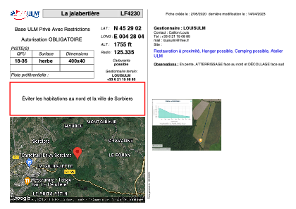
LF4230 - La jalabertière
Located in Saint-Chamond, France
ICAO - , IATA -
Data provided by AirmateGeneral information
Coordinates: N45°29'2" E4°28'4"
Elevation is 1755 feet MSL.
View others Airports in Rhône Alpes
Operational data
Special qualification required
Current time UTC:
Current local time:
Weather at : LFMH - Saint Etienne Loire ( 14 km )
METAR: LFMH 101700Z AUTO 05005KT CAVOK 19/02 Q1022
Communications frequencies: [VIEW]
Runways:
| RWY identifier | QFU | Length (ft) | Width (ft) | Surface | LDA (ft) |
| 18 | 0° | 1312 | 131 | GRASS | |
| 36 | 0° | 1312 | 131 | GRASS |
Airport contact information
Address: Saint-Chamond France
Satellite view of LF4230
Sorry, we have no imagery here.
Sorry, we have no imagery here.
Sorry, we have no imagery here.
Sorry, we have no imagery here.
Sorry, we have no imagery here.
Sorry, we have no imagery here.