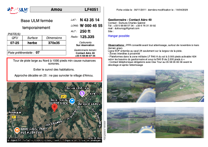
VAC chart of LF4051
 Satellite view of LF4051
Satellite view of LF4051
Sorry, we have no imagery here.
Sorry, we have no imagery here.
Sorry, we have no imagery here.
Sorry, we have no imagery here.
Sorry, we have no imagery here.
Sorry, we have no imagery here.


LF4051 - Amou
Located in Amou, France
ICAO - , IATA -
Data provided by AirmateGeneral information
Coordinates: N43°35'14" W0°45'55"
Elevation is 250 feet MSL.
View others Airports in Aquitaine
Operational data
Special qualification required
Current time UTC:
Current local time:
Weather at : LFBY - Dax Seyresse ( 27 km )
METAR: LFBY 022200Z AUTO 14004KT 5000 // ////// 13/11 Q1007
Communications frequencies: [VIEW]
Runways:
| RWY identifier | QFU | Length (ft) | Width (ft) | Surface | LDA (ft) |
| 07 | 0° | 1213 | 114 | GRASS | |
| 25 | 0° | 1213 | 114 | GRASS |
Airport contact information
Address: Amou France
Satellite view of LF4051
Sorry, we have no imagery here.
Sorry, we have no imagery here.
Sorry, we have no imagery here.
Sorry, we have no imagery here.
Sorry, we have no imagery here.
Sorry, we have no imagery here.