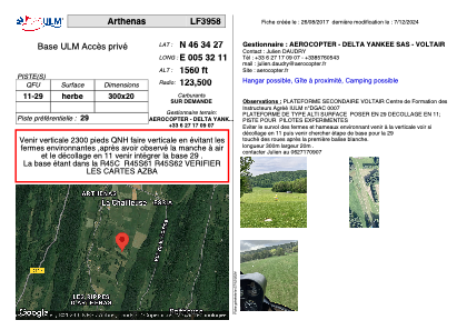
VAC chart of LF3958
 Satellite view of LF3958
Satellite view of LF3958
Sorry, we have no imagery here.
Sorry, we have no imagery here.
Sorry, we have no imagery here.
Sorry, we have no imagery here.
Sorry, we have no imagery here.
Sorry, we have no imagery here.


LF3958 - Arthenas
Located in La Chailleuse, France
ICAO - , IATA -
Data provided by AirmateGeneral information
Coordinates: N46°34'27" E5°32'11"
Elevation is 1560 feet MSL.
View others Airports in Franche-Comté
Operational data
Special qualification required
Current time UTC:
Current local time:
Weather at : LFGJ - Dole Tavaux ( 53 km )
METAR: LFGJ 101230Z AUTO 02013KT 350V060 CAVOK 20/03 Q1024 NOSIG
TAF: TAF LFGJ 101100Z 1012/1021 03012KT CAVOK TEMPO 1012/1018 02012G22KT
Communications frequencies: [VIEW]
Runways:
| RWY identifier | QFU | Length (ft) | Width (ft) | Surface | LDA (ft) |
| 11 | 0° | 984 | 65 | GRASS | |
| 29 | 0° | 984 | 65 | GRASS |
Airport contact information
Address: La Chailleuse France
Web: aerocopter.fr
Satellite view of LF3958
Sorry, we have no imagery here.
Sorry, we have no imagery here.
Sorry, we have no imagery here.
Sorry, we have no imagery here.
Sorry, we have no imagery here.
Sorry, we have no imagery here.