VAC chart of LF3825
 Satellite view of LF3825
Satellite view of LF3825
Sorry, we have no imagery here.
Sorry, we have no imagery here.
Sorry, we have no imagery here.
Sorry, we have no imagery here.
Sorry, we have no imagery here.
Sorry, we have no imagery here.


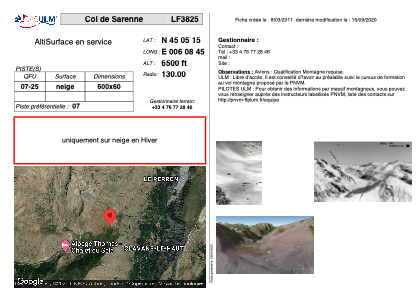
LF3825 - Col de Sarenne
Located in Clavans en Haut Oisans, France
ICAO - , IATA -
Data provided by AirmateGeneral information
Coordinates: N45°5'15" E6°8'45"
Elevation is 6500 feet MSL.
View others Airports in Rhône Alpes
Operational data
Special qualification required
Current time UTC:
Current local time:
Weather at : LFLB - Chambery Aix Les Bains ( 65 km )
METAR: LFLB 102000Z AUTO VRB02KT CAVOK 11/05 Q1021 NOSIG
TAF: TAF LFLB 101400Z 1015/1115 01010KT CAVOK BECMG 1102/1104 VRB02KT
Communications frequencies: [VIEW]
Runways:
| RWY identifier | QFU | Length (ft) | Width (ft) | Surface | LDA (ft) |
| 07 | 0° | 1968 | 196 | SNOW | |
| 25 | 0° | 1968 | 196 | SNOW |
Airport contact information
Address: Clavans en Haut Oisans France
Satellite view of LF3825
Sorry, we have no imagery here.
Sorry, we have no imagery here.
Sorry, we have no imagery here.
Sorry, we have no imagery here.
Sorry, we have no imagery here.
Sorry, we have no imagery here.