VAC chart of LF3821
 Satellite view of LF3821
Satellite view of LF3821
Sorry, we have no imagery here.
Sorry, we have no imagery here.
Sorry, we have no imagery here.
Sorry, we have no imagery here.
Sorry, we have no imagery here.
Sorry, we have no imagery here.


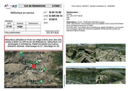
LF3821 - Col de Belledonne
Located in Revel, France
ICAO - , IATA -
Data provided by AirmateGeneral information
Coordinates: N45°9'60" E5°59'14"
Elevation is 9120 feet MSL.
View others Airports in Rhône Alpes
Operational data
Special qualification required
Current time UTC:
Current local time:
Weather at : LFLB - Chambery Aix Les Bains ( 53 km )
METAR: LFLB 111330Z AUTO 01003KT 320V060 CAVOK 22/07 Q1018 NOSIG
TAF: TAF LFLB 110800Z 1109/1209 36006KT CAVOK BECMG 1117/1119 VRB03KT
Communications frequencies: [VIEW]
Runways:
| RWY identifier | QFU | Length (ft) | Width (ft) | Surface | LDA (ft) |
| 07 | 0° | 0 | 0 | SNOW | |
| 25 | 0° | 0 | 0 | SNOW |
Airport contact information
Address: Revel France
Satellite view of LF3821
Sorry, we have no imagery here.
Sorry, we have no imagery here.
Sorry, we have no imagery here.
Sorry, we have no imagery here.
Sorry, we have no imagery here.
Sorry, we have no imagery here.