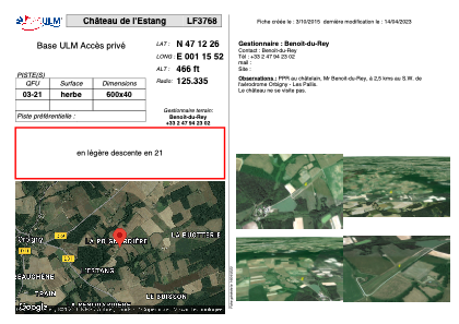
VAC chart of LF3768
 Satellite view of LF3768
Satellite view of LF3768
Sorry, we have no imagery here.
Sorry, we have no imagery here.
Sorry, we have no imagery here.
Sorry, we have no imagery here.
Sorry, we have no imagery here.
Sorry, we have no imagery here.


LF3768 - Château de l'Estang
Located in Orbigny, France
ICAO - , IATA -
Data provided by AirmateGeneral information
Coordinates: N47°12'26" E1°15'52"
Elevation is 466 feet MSL.
View others Airports in Centre
Operational data
Special qualification required
Current time UTC:
Current local time:
Weather at : LFYR - Romorantin Pruniers ( 34 km )
METAR: LFYR 111030Z AUTO 04006KT 340V090 CAVOK 20/05 Q1020 NOSIG
TAF: TAF LFYR 110800Z 1109/1209 05007KT CAVOK
Communications frequencies: [VIEW]
Runways:
| RWY identifier | QFU | Length (ft) | Width (ft) | Surface | LDA (ft) |
| 03 | 0° | 1968 | 131 | GRASS | |
| 21 | 0° | 1968 | 131 | GRASS |
Airport contact information
Address: Orbigny France
Satellite view of LF3768
Sorry, we have no imagery here.
Sorry, we have no imagery here.
Sorry, we have no imagery here.
Sorry, we have no imagery here.
Sorry, we have no imagery here.
Sorry, we have no imagery here.