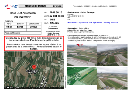
VAC chart of LF3553
 Satellite view of LF3553
Satellite view of LF3553
Sorry, we have no imagery here.
Sorry, we have no imagery here.
Sorry, we have no imagery here.
Sorry, we have no imagery here.
Sorry, we have no imagery here.
Sorry, we have no imagery here.


LF3553 - Mont Saint Michel
Located in Saint-Georges-de-Gréhaigne, France
ICAO - , IATA -
Data provided by AirmateGeneral information
Coordinates: N48°36'16" W1°33'6"
Elevation is 16 feet MSL.
View others Airports in Lower Normandy
Operational data
Special qualification required
Current time UTC:
Current local time:
Weather at : LFRD - Dinard Pleurtuit Saint Malo ( 39 km )
METAR: LFRD 070030Z AUTO 05005KT CAVOK 08/06 Q1020 TEMPO 0400 FG VV///
TAF: TAF LFRD 062300Z 0700/0724 VRB05KT CAVOK TEMPO 0702/0707 3000 BR PROB40 TEMPO 0702/0707 0400 FG VV/// BECMG 0712/0714 02010KT BECMG 0720/0722 VRB05KT
Communications frequencies: [VIEW]
Runways:
| RWY identifier | QFU | Length (ft) | Width (ft) | Surface | LDA (ft) |
| 03 | 0° | 984 | 114 | GRASS | |
| 21 | 0° | 984 | 114 | GRASS |
Airport contact information
Address: Saint-Georges-de-Gréhaigne France
Satellite view of LF3553
Sorry, we have no imagery here.
Sorry, we have no imagery here.
Sorry, we have no imagery here.
Sorry, we have no imagery here.
Sorry, we have no imagery here.
Sorry, we have no imagery here.