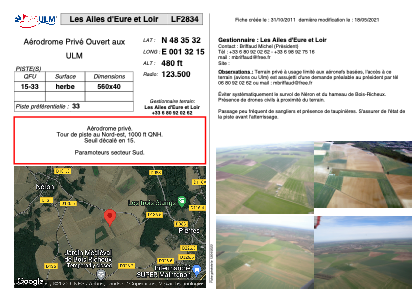
VAC chart of LF2834
 Satellite view of LF2834
Satellite view of LF2834
Sorry, we have no imagery here.
Sorry, we have no imagery here.
Sorry, we have no imagery here.
Sorry, we have no imagery here.
Sorry, we have no imagery here.
Sorry, we have no imagery here.


LF2834 - Les Ailes d'Eure et Loir
Located in Pierres, France
ICAO - , IATA -
Data provided by AirmateGeneral information
Coordinates: N48°35'32" E1°32'15"
Elevation is 480 feet MSL.
View others Airports in Centre
Operational data
Special qualification required
Current time UTC:
Current local time:
Communications frequencies: [VIEW]
Runways:
| RWY identifier | QFU | Length (ft) | Width (ft) | Surface | LDA (ft) |
| 15 | 0° | 1837 | 131 | GRASS | |
| 33 | 0° | 1837 | 131 | GRASS |
Airport contact information
Address: Pierres France
Satellite view of LF2834
Sorry, we have no imagery here.
Sorry, we have no imagery here.
Sorry, we have no imagery here.
Sorry, we have no imagery here.
Sorry, we have no imagery here.
Sorry, we have no imagery here.